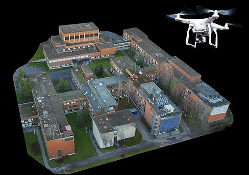
3D MODELING
Aerial mapping and modeling is a new and innovative way of capturing a property. This service offers amazing detail and an interactive 3D model to present to the customer. This is great for clients looking to showcase their property in a modern and interactive way to the public.
SURVEYING
Topographical and Orthomosaic surveying is a great way for clients to review and analyze their property. This service offers things like an amazing bird eye map with extreme detail, elevation changes, building size, measurement tools, and more.


AGRICULTURE
Our team is based out of Mechanicsville, MD. We a very appreciative of all our local farmers and their work. With our aerial NDVI (normalized difference vegetation index) process we can analyze farmers crop growth and help them determine what areas will need attention for best results.